搜索结果: 1-15 共查到“测绘科学技术 RS”相关记录52条 . 查询时间(0.077 秒)

中国石油大学(华东)2021年硕士研究生初试自命题科目GNSS、RS、GIS原理与方法考试大纲
中国石油大学(华东) 2021年 硕士研究生 初试 自命题科目 GNSS、RS、GIS原理与方法 考试大纲
2020/10/14
中国石油大学(华东)2021年硕士研究生初试自命题科目GNSS、RS、GIS原理与方法考试大纲。

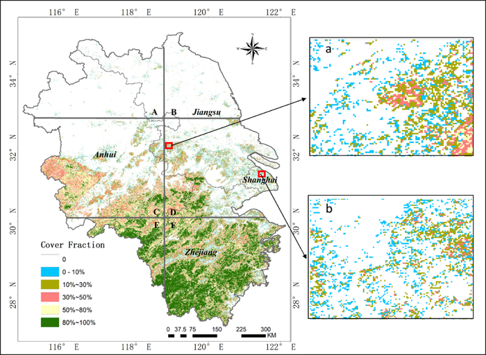
地学院测绘系18级博士生杨莹莹同学论文‘Fractional evergreen forest cover mapping by MODIS time-series FEVC-CV methods at sub-pixel scales’被一区期刊 ISPRS Journal of Photogrammetry and Remote Sensing接收发表,基于中等分辨率遥感时间序列数据实现了大尺...
应用遥感与地理信息系统技术构建基于GIS模型的蓄滞洪区空间数据库,对蓄滞洪区内的基础地理数据进行存储、管理,并对空间数据进行可视化和空间分析等操作;运用RS技术对蓄滞洪区内的土地利用、生态环境变化等情况进行动态监测,建立蓄滞洪区发展指标体系;探求蓄滞洪区的和谐发展模式,为蓄滞洪区的可持续发展提供科学依据。
RS-BASED WATER RESOURCES INVENTORY OF THE PHILIPPINES: CAPACITY BUILDING EFFORTS FOR NATIONWIDE IMPLEMENTATION
Capacity Building Hydrologic Data Geodatabase Water Resource Inventory Water Resource Mapping LIDAR
2016/11/15
Considering that the Philippines is archipelagic in nature and is exposed to disasters accentuated by climate change, water resource monitoring and management has been an important concern in the coun...
THE RS IMAGES RESTORATION OF CBERS-2 BASED ON ATMOSPHERIC MTF EVALUATION USING METEOROLOGICAL DATA
Images Restoration RS images Atmospheric MTF Meteorological Data CBERS-2 satellite Turbulence and aerosols
2015/12/28
Atmospheric MTF(Modulation Transfer Function) takes a critical role in restoration of atmospheric blurred RS(Remote Sensing) images. This MTF can be determined by meteorological data. Among the existi...
A STUDY ON THE EXTRACTION OF MULTI-FACTOR INFLUENCING FLOODS FROM RS IMAGE AND GIS DATA;A CASE STUDY IN NACKDONG BASIN,S.KOREA
Spatial Information Sciences Risk Model Terrestrial Photogrammetry Feature Extraction Flood Management Hazard Mapping
2015/12/28
The climate changes will be much more significant over the next 100 years and may lead to the heavy rainfall event. The heavy rainfall causes the flood hazard in the lowlands and geologic hazard in th...
A RESARCH ON THE ASSESSMENT OF REGIONAL ECOLOGICAL SECURITY BASED ON GIS&RS
Ecological security Spatial-temporal change Assessment RS GIS
2015/12/23
Ecological security is an important basis of the entire human security system, the cornerstone for human survival. The assessment of ecological security is crucial for making decisions to avoidecologi...
Evacuation Planning in Earthquake Disasters, Using RS & GIS
Evacuation Planning Disaster Management Optimization RS GIS
2015/12/18
In this research a three-step method was adopted for evacuation planning. At the first step appropriate safe places for evacuation were identified and extracted using RS and image processing technique...
A Study on RS Image Sharing Based on Data Grid
Data Grid Metadata Globus Spatial Data Sharing Geo-spatial Information Service
2015/12/18
Based upon the in-depth analysis of the remote sensing image sharing demand and the status of the current research on it, this paper points out the existing Web-based sharing-model did not eliminate "...
RS-Based Landscape Dynamic Evolution in Areas of Cascade Hydropower Station Construction in the Upper Yellow River
Satellite Remote Sensing Geographic Information System Landscape Metrics
2015/12/11
With the increasing demand for energy sources, a further development hydropower energy resource will be an inevitable choice for China’s resource strategy. The cascade hydropower station construction ...
Research on the Edge of RS Image Based on Cloud Model
Image Edge Model Spectral Fuzzy Logic Cloud model
2015/12/1
To extract rules for detecting edges, it is helpful to have some familiarity with different kinds of edges in order to construct a suitable characterization. Typically, researchers have characterized ...
SUSTAINABLE DEVELOPMANT OF FOREST RESOURSE THROUGH RS & GIS TECHNIQUES- A CASE STUDY IN R V NAGAR RANGE, VISAKHAPATNAM DISTRICT, ANDHRA PRADESH
Forest cover change Species Richness Threat Index
2015/8/28
Forest ecosystem is a complex system having interactions with biotic and abiotic components. It includes not only plant and animal
communities but also microorganisms, climate, sunlight, water and so...
The authors are developing educational material package for remote sensing called RS-fun with Macromedia Flash software. RS-fun
is developed under the concept of “edutainment”(education + entertainm...


